| Kathleen K. Reyes | 2024-04-15 |
expert map | Team reviewed:
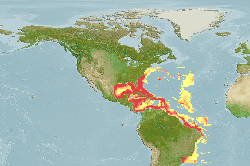
Thunnus atlanticus. Map edits based on comparison of distribution information and maps from FAO, IUCN, SAU, FishBase, and AquaMaps good cell data.
Pelagic: TRUE to FALSE
bbox: 43/-28/-100/-26 to 41/-28/-98/-28
Depth: 50/170/463/1000 to 0/50/-/4000
SST: 13.45/23.47/28.03/32.23 to 14.8/-/-/- ... More
Modify | 773 |  |