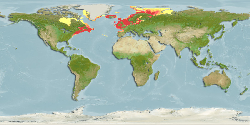
| Kathleen K. Reyes | 2021-06-15 |
expert map | Team reviewed:
Adjusted western limit from 79°W to 95°W, and FAO area 18 added as species reported from Hudson Bay Complex (FishBase Ref. 117245). Surface salinity minimum and preferred minimum adjusted from 3.36 to 2.9, and from 13.4 to 6.0, respectively. Primary production minimum and preferred minimum adjusted from... More
Modify | 2140 |  |
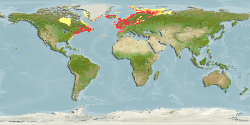
| Kathleen K. Reyes | 2021-06-15 |
expert map | Team reviewed:
Adjusted western limit from 79°W to 95°W, and FAO area 18 added as species reported from Hudson Bay Complex (FishBase Ref. 117245). Sea surface temperature minimum and maximum adjusted from -0.6°C to 0.02°C, and from 25.4°C to 22°C. Surface salinity minimum and preferred minimum adjusted from 3.36 to... More
Modify | 2140 | |
| 2020-05-12 00:00:00 |
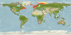
default map | Computer Generated Native Distribution Map | 2140 | |