| Kathleen K. Reyes | 2022-11-18 |
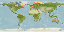
expert map | Team reviewed:
Adjusted SSTMin from 0.6°C to -0.3° to extend to NW Greenland coast. REmoved FAO area 18 to exclude probable false predicted presence in Gulf of Ob and Gulf of Yenisei (predicted presence in Ungava Bay however gets... More
Modify | 2171 |  |
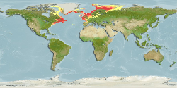
| Kathleen K. Reyes | 2021-06-15 |

expert map | Team reviewed:
Minimum surface salinity envelope adjusted from 3.6 to 5.5, while preferred minimum adjusted from 27.2 to 7.0 to limit prediction towards southern Gulf of Bothnia and western Gulf of Finland. Preferred minimum primary production also adjusted from 3.4 to 0.6. To improve predictions towards southern North Sea... More
Modify | 2171 | |
| 2020-05-12 00:00:00 |
default map | Computer Generated Native Distribution Map | 2171 | |