| Elizabeth Bato | 2023-01-18 |
expert map | Team reviewed:
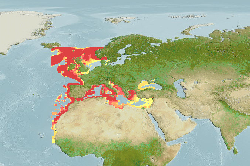
Adjusted southern and eastern limits from 14°N and 36°E to 12°N and 37°E, respectively. Increased maximum depth to 2000 m (Ref. 127904). Adjusted minimum salinity from 5.21 psu to 10 psu and unchecked point number 358 (62.25, 18.75) to exclude predicted occurrence in the Baltic Sea. Increased maximum... More
Modify | 354 |  |